

Trees will NOT explode in the cold weather
There is a wild and inaccurate rumor spreading online that extreme cold, which will blanket the Midwest, will make trees explode. FOX6 News shows you the truth about what will actually happen to the trees.
Fox – Milwaukee
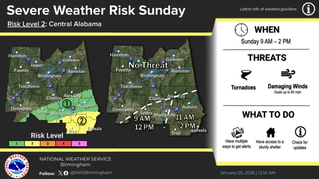
After a winter storm settled across Alabama, the state is waking up to a dramatic shift in weather conditions on Sunday, from lingering ice in the north to possible storms in the south, followed by dangerously cold air statewide.
Multiple National Weather Service advisories remain in effect across Alabama, with impacts ranging from slick roads and power outages to the risk of severe storms and extreme cold temperatures heading into early next week.
Here’s what to expect by region:
Huntsville weather forecast
North Alabama remains under the influence of the winter storm on Sunday, with steady rain continuing through early afternoon in the Huntsville area. Some of that rain could be heavy before temperatures slide quickly later in the day, falling toward the low 30s by late afternoon as winds shift and turn gusty.
By Sunday night, the real cold arrives. Temperatures are expected to drop into the mid-teens, with wind chills falling into the single digits, making for a bitter end to the weekend.
Montgomery weather forecast
Central Alabama will feel the full force of Sunday’s weather whiplash. Rain is expected through the morning, with showers and a thunderstorm developing around midday as temperatures briefly surge into the mid- to upper 60s.
Forecasters have placed much of the region under a level 1 to 2 out of 5 severe storm risk, mainly along and south of the U.S. 80 and I-85 corridors, where damaging wind gusts and a brief tornado are possible between late morning and early afternoon.
Gusty winds could reach 40 mph even outside of storms, raising the risk of downed trees and scattered power outages. Once the storm moves out, colder air rushes in, sending temperatures sharply downward into the 20s overnight.
Mobile weather forecast
Showers and thunderstorms are expected across south Alabama Sunday, with heavy rain and gusty winds developing as temperatures slide into the mid-50s by late afternoon. The region is under a slight risk for severe storms (1 out of 5), with damaging winds the primary threat, though a brief tornado cannot be ruled out as storms move through.
By Sunday night, attention shifts to the cold, as an extreme cold warning takes effect. Temperatures are expected to plunge into the mid-20s, with wind chills dropping into the teens, bringing dangerously cold conditions uncommon for the Gulf Coast.
See Alabama radar
Get weather updates in Alabama
Jennifer Lindahl is a Breaking and Trending Reporter for the Deep South Connect Team for USA Today. Connect with her on X @jenn_lindahl and email at jlindahl@usatodayco.com.
Source link

Khamrah by Lattafa for Men - 3.4 oz EDP Spray
4% Off
Ghost Sweetheart Eau de Toilette | Pineapple, Jasmine and Sandalwood | Perfume for Women 50 ml
50% Off
Marc Jacobs Dot Eau De Parfum for Women, 100 ml
42% Off
Ted Baker W Eau de Toilette for Her, Fig Leaf, White Peony and Violet Top Notes, Pink Orchid and Raspberry Middle Notes, 75ml
£11.77 (£15.69 / 100 ml) (as of 29/06/2026 03:52 GMT +01:00 - More infoProduct prices and availability are accurate as of the date/time indicated and are subject to change. Any price and availability information displayed on [relevant Amazon Site(s), as applicable] at the time of purchase will apply to the purchase of this product.)
Ted Baker Woman Pink Eau de Toilette Spray Floral Green Feminine Fragrance, Opening Notes are Fresh Peach, Bergamot and Tangerine with Warm Musk, Vanilla and Vetiver Base, 100ml
11% Off
Vera Wang Princess Eau de Toilette - 30 ml
Choco Musk 50ml Eau De Parfum for men and women | Chocolate Musk by Jannat Aromas
17% Off
Christina Aguilera Signature Eau de Parfum (50ml) Floral, Fruity & Exotic Scent, Luxury Fragrance for Women
9% Off
Calvin Klein - Eau De Toilette CKIN2U - Calvin Klein Women, Ladies Perfume, Women's Perfume, Calvin Klein Perfume, Calvin Klein One - 150 ml
5% Off
Jimmy Choo Flash Eau de Parfum, 60 ml (Pack of 1)
3% Off
Fruit of the Loom Men's Heavy T Shirt, White, XL UK
28% Off
ATNKE LED Lighted Beanie Cap,USB Rechargeable Running Hat Ultra Bright 4 LED Waterproof Light Winter Warm Gifts for Men and Women/Pink
17% Off
Men's 1/4 Zip Pullover UK Sale Clearance, Fleece Sweatshirt Casual Jumper Long Sleeve T-shirt Top Stand Collar Sweater Plain Pullover Sports Leisure Workwear Quarter Zip Sweater Lightweight Jumpers
£5.88 (as of 12/11/2025 00:52 GMT +01:00 - More infoProduct prices and availability are accurate as of the date/time indicated and are subject to change. Any price and availability information displayed on [relevant Amazon Site(s), as applicable] at the time of purchase will apply to the purchase of this product.)
Crevice Cleaning Brush, Bathroom Tile Groove Gap Cleaning Brush,Premium Crevice Cleaning Tool Aluminum Support with 15° Angle Magic Brush, Thin Brush for Home Kitchen
19% Off
Wireless Earbuds, Bluetooth 5.3 Headphones in Ear with HiFi Stereo Deep Bass, 4 ENC Noise Cancelling Mic Wireless Earphones 40H Playtime, Bluetooth Earbuds Dual LED Display, IP7 Waterproof, USB-C
42% Off


