

Winter storm prep tips to stay safe
Learn what to pack, how to protect your home and how to stay safe during a winter storm in this essential safety guide.
Today is the day! After nearly a week of warnings and preparation, what the Weather Channel calls ‘Winter Storm Fern’ will hit Georgia residents this afternoon. At this point, it’s now looking more icy than snowy.
Here are the latest forecasts from the National Weather Service and the Weather Channel:
Athens weather forecast
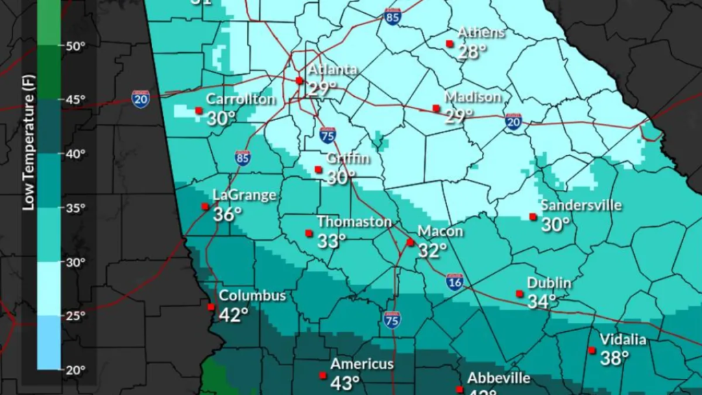
Athens will be under an ice storm warning starting at 1 p.m. Saturday through 10 a.m. Monday. Total ice accumulations between a quarter of an inch and one inch are expected. Power outages and tree damages are possible, and travel may be impossible.
Showers are not likely to start until around 10 p.m. Sleet is likely later tonight, mixing with freezing rain. New sleet accumulation of less than half an inch possible. The freezing rain is expected to last through 4 p.m. tomorrow and will turn back into showers Sunday evening.
This weekend’s winds will be about 10 mph with gusts as high as 20-25 mph. There’s also a 43% chance of at least some snow.
Temperatures are currently sitting in the 40’s, but will drop into the 30’s later tonight and the 20’s by Sunday morning. It will rise back into the 30’s for most of Sunday.
Atlanta weather forecast
Atlanta will be under the same ice storm warning as Athens later today, with the same amount of ice accumulation expected.
Rain is not likely to start until around 9 p.m. It will turn into freezing rain after 1 a.m. possibly mixed with a little sleet until 2 a.m. The freezing rain is expected to continue through 1 p.m. tomorrow followed by rain showers through midnight.
This weekend’s winds will be about 10-15 mph with gusts as high as 25-30 mph. There’s also a 8% chance of at least some snow.
Temperatures are currently sitting in the 40’s, but will drop into the 30’s later tonight, staying around freezing point Sunday morning. It will rise back into the 40’s for most of Sunday afternoon.
Live weather radar for Atlanta and Athens
Augusta weather forecast
Augusta will be under an ice storm warning starting at 1 p.m. today through 1 p.m. Monday. Total sleet accumulations up to one-half inch and ice accumulations between two-tenths and three-tenths of an inch. Roads, especially bridges and overpasses, will likely become slick and hazardous. Power outages and tree damage are likely , and travel could be impacted through Monday morning.
Showers are not likely to start until around 10 p.m. turning into freezing rain 1-10 a.m. Rain will continue tomorrow with a possible thunderstorm Saturday night. This weekend’s winds will be about 6-9 mph. There’s also a 3% chance of at least some snow.
Temperatures are currently sitting in the 40’s, but will drop into the 30’s later tonight, staying around freezing point Sunday morning. It will rise back into the 40’s for most of Sunday afternoon.
Live weather radar Augusta
Savannah weather forecast
Savannah will largely avoid the ice storm. There is a hazardous weather outlook showing ice accumulation for today and tomorrow, but there’s no measurable amount on the NWS maps. Extreme cold is expected though after this weekend.
There’s a slight chance of a little rain starting before 2 a.m. with a break tomorrow until Sunday night when showers and possibly a thunderstorm are expected. This weekend’s winds will be about 6-11 mph with gusts as high as 20 mph. Don’t expect any snow.
Temperatures are currently sitting around 50 degrees, lowering into the 40’s later this evening. It won’t drop below 40 today or tomorrow though. In fact, it will get back up into the 60’s by Sunday afternoon.
Live weather radar Savannah
Miguel Legoas is a Deep South Connect Team Reporter for USA Today. Find him on Instagram @miguelegoas and email at mlegoas@gannett.com.
Source link

Khamrah by Lattafa for Men - 3.4 oz EDP Spray
4% Off
Ghost Sweetheart Eau de Toilette | Pineapple, Jasmine and Sandalwood | Perfume for Women 50 ml
50% Off
Marc Jacobs Dot Eau De Parfum for Women, 100 ml
42% Off
Ted Baker W Eau de Toilette for Her, Fig Leaf, White Peony and Violet Top Notes, Pink Orchid and Raspberry Middle Notes, 75ml
£11.77 (£15.69 / 100 ml) (as of 04/07/2026 03:54 GMT +01:00 - More infoProduct prices and availability are accurate as of the date/time indicated and are subject to change. Any price and availability information displayed on [relevant Amazon Site(s), as applicable] at the time of purchase will apply to the purchase of this product.)
Ted Baker Woman Pink Eau de Toilette Spray Floral Green Feminine Fragrance, Opening Notes are Fresh Peach, Bergamot and Tangerine with Warm Musk, Vanilla and Vetiver Base, 100ml
11% Off
Vera Wang Princess Eau de Toilette - 30 ml

Choco Musk 50ml Eau De Parfum for men and women | Chocolate Musk by Jannat Aromas
17% Off
Christina Aguilera Signature Eau de Parfum (50ml) Floral, Fruity & Exotic Scent, Luxury Fragrance for Women
9% Off
Calvin Klein - Eau De Toilette CKIN2U - Calvin Klein Women, Ladies Perfume, Women's Perfume, Calvin Klein Perfume, Calvin Klein One - 150 ml
5% Off
Jimmy Choo Flash Eau de Parfum, 60 ml (Pack of 1)
3% Off
Fruit of the Loom Men's Heavy T Shirt, White, XL UK
28% Off
ATNKE LED Lighted Beanie Cap,USB Rechargeable Running Hat Ultra Bright 4 LED Waterproof Light Winter Warm Gifts for Men and Women/Pink
17% Off
Men's 1/4 Zip Pullover UK Sale Clearance, Fleece Sweatshirt Casual Jumper Long Sleeve T-shirt Top Stand Collar Sweater Plain Pullover Sports Leisure Workwear Quarter Zip Sweater Lightweight Jumpers
£5.88 (as of 12/11/2025 00:52 GMT +01:00 - More infoProduct prices and availability are accurate as of the date/time indicated and are subject to change. Any price and availability information displayed on [relevant Amazon Site(s), as applicable] at the time of purchase will apply to the purchase of this product.)
Crevice Cleaning Brush, Bathroom Tile Groove Gap Cleaning Brush,Premium Crevice Cleaning Tool Aluminum Support with 15° Angle Magic Brush, Thin Brush for Home Kitchen
19% Off
Wireless Earbuds, Bluetooth 5.3 Headphones in Ear with HiFi Stereo Deep Bass, 4 ENC Noise Cancelling Mic Wireless Earphones 40H Playtime, Bluetooth Earbuds Dual LED Display, IP7 Waterproof, USB-C
42% Off


